
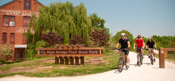
High Bridge Trail State Park
1466 Camp Paradise Road, Rice, VA 23966; Phone: 434-480-5835; Email: highbridgetrail@dcr.virginia.gov
Latitude, 37.304488. Longitude, -78.390938.


Photos and video


Open fires are prohibited throughout the park from midnight to 4 p.m., now through April 30. Learn more.
This content takes priority over any other information provided on this park's webpage.
The park is open sunrise to dusk.
River Road and Camp Paradise parking lots open at 8 a.m. All other parking lots open at sunrise.
All restroom facilities are open.
Please review the Virginia State Parks Know Before You Go information before you visit.
General Information
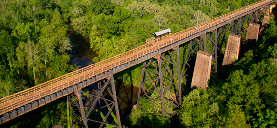
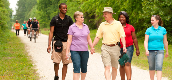
High Bridge Trail is 32.2 miles long and ideally suited for hiking, bicycling and horseback riding. Once a rail bed, the trail is wide, level and generally flat. Its finely crushed limestone surface and dimensions make it easy to enjoy. The park’s centerpiece is the majestic High Bridge, which is more than 2,400 feet long and 125 feet above the Appomattox River. It is the longest recreational bridge in Virginia and among the longest in the United States. High Bridge, a Virginia Historic Landmark, is on the National Register of Historic Places. The trail is a National Recreation Trail recognizing exemplary trails of local and regional significance, connecting people to nature, to each other, and to our shared history and culture. Bring drinking water because none is available on the trail.
High Bridge access
There are two parking lots near High Bridge.
East of the bridge: 1466 Camp Paradise Road; Rice, Virginia (Prince Edward County)
- Use 1681 Aspen Hill Road Rice, Virginia 23966, to get to the entrance of Camp Paradise Road then travel 1.5 miles to the parking area.
- High Bridge is .3 miles from the High Bridge Station parking lot. There is trailer parking just before the main parking lot, .6 miles east of High Bridge.
West of the bridge: River Road, Farmville (Cumberland County)
- Use 555 River Road, Farmville, VA 23901, to get here. High Bridge is nearly a mile from the lot. Trailers are not allowed at this lot.
Trip suggestions
- Bikers might prefer parking at the Rice parking lot, which is 3.2 miles from the bridge and 8.2 miles from Farmville. Bikers might also wish to park at the Main Street Plaza parking lot in Farmville; the bridge is 4.5 miles from that lot.
- For equestrians, the designated horse trailer parking lots are at Camp Paradise Road. (.6 miles from the bridge) and Prospect (14.1 miles from the bridge).
Hours
Dawn - dusk.
Location
High Bridge Trail traverses Cumberland, Nottoway and Prince Edward Counties and the towns of Burkeville, Farmville, Pamplin City, Prospect and Rice. The address listed above is for mail.
Entrances - Parking availability:
- Rice - 642 Rice's Depot Road, 1/4-mile off U.S. 460 at Rice, near trail milepost 3.5E*
- High Bridge Station - 1466 Camp Paradise Road, Rice; 3.2 miles off 460/Aspen Hill Road in Rice, near trail milepost 0.5E*
- River Road - 555 River Road, 3 miles off N. Main Street in Farmville, near trail milepost 1W*
- Municipal lots in Farmville where the trail intersects with Main Street near trail milepost 4.5W
- Tuggle - 4525 Hardtimes Road, Prospect; off U.S. 460 and near U.S. 15 North, near trail milepost 10.5W*
- Prospect - 187 Prospect Road, off U.S. 460 at Prospect, near trail milepost 13W*
- Elam - Off U.S. 460 at Sulphur Springs Road near trail milepost 18W*
- Pamplin – Off U.S. 460 on 1779 Pamplin Road at trail milepost 21.9W*
* Pay lots. You may use cash, check, Visa, MasterCard, Discover, or American Express at self-pay lots.
Restroom Facilities:
- Piney Grove – Vault Toilet – Mile Marker 6.5 E – Located .9 miles west from Moran Road.
- Rice – Vault Toilet – Mile Marker 3.5 E – Located on the east side of the parking lot.
- High Bridge Station – Vault Toilet and Flush Toilets – near Mile Marker .5 E – Located at the Camp Paradise parking lot.
- River Road – Vault Toilet – Mile Marker 1.0 W – Located down the path, behind the electric substation.
- Main Street, Downtown Farmville – Flush Toilets (owned and maintained by the Town of Farmville) – Located on the High Bridge Plaza.
- Tuggle – Vault Toilet – Mile Marker 10.5 W – Located just east of the Tuggle parking lot.
- Prospect – Vault Toilet –Mile Marker 14.0 W – Located on the east side of the Prospect parking lot.
- Heights School – Vault Toilet – Mile Marker 20.5 W
- Pamplin – Portajohn – Mile Marker 21.9 W – Located at the parking lot at 1779 Pamplin Road.
Park Size
1,291 acres.
Share this page


Blogs
- Commemorating the 160th battle anniversary: Q&A with the chief historic weapons safety officer
- A Virginia State Parks road trip for Black History Month
- Holiday shopping at Virginia State Parks
- Adventure Series running events are not your run-of-the-mill races
- Fall foliage at Virginia State Parks: Peak periods by region
- More blogs about this park.
At a Glance


