Open fires are prohibited throughout the park from midnight to 4 p.m., Feb. 15 through April 30. Learn more.
Grayson Highlands State Park
829 Grayson Highland Ln., Mouth of Wilson, VA 24363; Phone: 276-579-7092; Email: GraysonHighlands@dcr.virginia.gov
Latitude, 36.628322. Longitude, -81.496889.


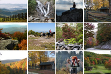
Photos and video


This content takes priority over any other information provided on this park's webpage EXCEPT for the site alert.
The park is open daily from 8 a.m. – 10 p.m. The park office is open Mon. through Fri. from 9 a.m. – 4 p.m.
The Visitor Center is closed for the season.
Country Store is closed and will reopen after completion of the Hickory Ridge campground improvements.
Be sure to plan in advance for your trip: click here.
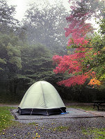
The park offers full-service camping May through October and reservations are strongly recommended. Primitive camping (no water or bath house) is available Nov., Mar. and April.
Please review the Virginia State Parks Know Before You Go information before you visit.
General Information
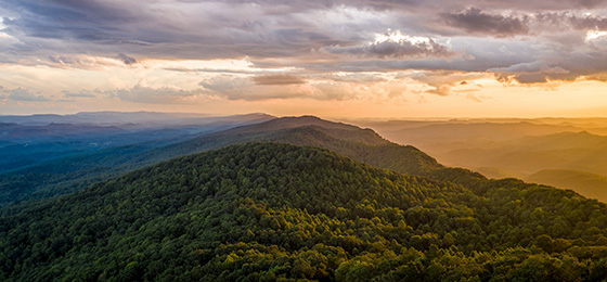
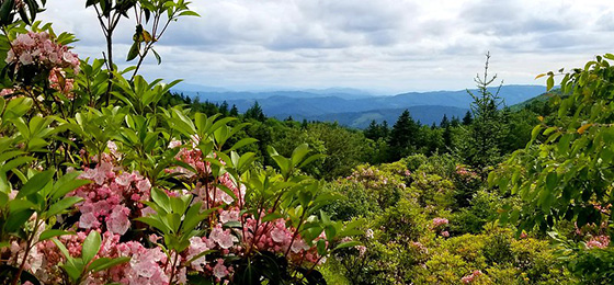
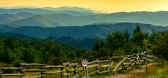
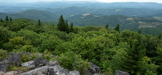
Near Mount Rogers and Whitetop Mountain, Virginia's two highest mountains, Grayson Highlands offers scenic views of alpine-like peaks more than 5,000 feet in elevation. Facilities include a visitor center, campgrounds, and hiking trails leading to waterfalls and overlooks. Scenic horse trails and a horse camping area with electric and water hookups, stables and parking for trailers are available. The park provides year-round access to the Appalachian Trail and the Virginia Highlands Horse Trail.
Hikers on the highlands trails are likely to encounter wild ponies. They were introduced to the park in 1974 to prevent reforestation of the highland balds. The Wilburn Ridge Pony Association manages the pony herd. During fall roundups of ponies for an auction held in conjunction with Grayson Highland’s annual Fall Festival, association members check the herd for health problems.
Visitors should not approach, feed or pet the ponies. They bite and kick when they feel threatened, and human food is bad for them.
This page's recreation section has specific information about hiking the high country.
Hours
8 a.m. - 10 p.m.
Location
The park is on U.S. 58 midway between Independence and Damascus and is reached from I-81 at Exit 45 in Marion; turn south on Route 16 and travel 24 miles to US 58 in the community of Volney. Turn right onto US 58. Travel eight miles to the park's entrance. Latitude, 36.628322. Longitude, -81.496889.
From I-77, take Hillsville Exit 14 to U.S. 58. Travel west on U.S. 58, 40 miles to Volney. Turn left to stay on U.S. 58 and go eight miles to the park entrance.
Its address is 829 Grayson Highland Lane, Mouth of Wilson, VA 24363; Latitude, 36.628322. Longitude, -81.496889.
Drive Time: Charlotte, 1.5 hours; Raleigh, 4 hours; Richmond, 5.5 hours; Roanoke, 2.5 hours; Northern Virginia, 6.5 hours; Tidewater, Norfolk, Virginia Beach, 7.5 hours; TriCities, Tennessee, 1.5 hours; Winston-Salem, 1.5 hours
Park Size
4,520 acres. Various elevation: Entrance - 3,698 feet; Visitor Center - 4,953 feet; Little Pinnacle - 5,089 feet.
Follow us

Cabins, camping
OVERNIGHT FACILITIES
 Camping, a bunkhouse and yurts. Grayson Highlands does not have cabins available for reservation. For information on the availability of overnight accommodations, and particular park amenities, or to make a reservation, you can reserve online or call 1-800-933-PARK. Rental rates for cabins and camping vary by season, dwelling and park. You might want to read the details regarding reservation cancellation and transfer policies. A fee is charged per pet per night for overnight stays in the bunkhouse.
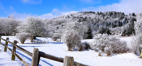
Note: Due to adverse weather conditions, full-service camping is only available from May through October. Primitive camping is allowed in Chestnut Hollow campground during March, April and November; there are porta-johns only; water is unavailable at this location. Each site has 20, 30 and 50 amp electrical service. Drinking water is available in the park office. Camping fees are lower during the primitive camping season. No camping is available from the first Monday in December until the first Friday in March.
Yurts
 Recreational yurts are a modern adaptation of an ancient nomadic shelter. Functionally speaking, it's a cross between a tent and a cabin. Grayson Highlands has four yurts in Hickory Ridge Campground. Each yurt has a large wooden deck with a picnic table and four rocking chairs. There is an additional area with a picnic table and a fire ring with cooking grate. Reservations are required. Parking for two vehicles allowed. Those with additional vehicles must pay a daily parking fee.
Check-in is 4 p.m. and checkout is 10 a.m. The rental season begins on May 1 and ends on the first Sunday of November. Cabin rental and cancellation policies apply. There's a two-night minimum rental during rest of camping season.
- Maximum occupancy 4. Sleeps 3 - One queen-sized and a twin-sized trundle pull-out. Guests must bring sleeping bags or linens.
- No smoking, cooking or pets allowed in the yurt.
- No electricity or water. Potable water is across the road from yurt 3.
- Dining table seats four.
- No heat or air-conditioning.
- Yurt 4 is accessible.
- Yurt 1 is 24 feet from the parking area and 463 feet from the bathhouse. Yurt 2 is 90 feet from the parking area and 730 feet from the bathhouse. Yurt 3 is 84 feet from the parking area and 500 feet from the bathhouse. Yurt 4 is 32 feet from the parking lot and 328 feet from the bathhouse.
Bunkhouse
Bunkhouse - Two-night minimum, no weekly requirement. This is not a full service lodge; it is a camping facility. The two-room trailer has seven bunk beds, a refrigerator, a microwave, a coffeepot, and heating and air conditioning. Just outside is a deck with two picnic tables and a charcoal grill. Cooking and smoking are not permitted inside the lodge. Four vehicles are permitted with rental of the lodge; all other vehicles must pay the park's daily parking fee. Because of the lodge's location, parking there is limited to three vehicles. Other vehicles may be parked across from the Country Store. This facility is not sold 11 months in advance; it goes online in January each year. It's available only during camping season, from May 1 to Oct 31 annually. Check-in is 4 p.m., and check-out is 10 a.m.
The transfer deadline policy and cancellation and pet fees are the same as those for cabins.
- Linens are not provided. Guests must bring their own linens and pillows.
- Maximum 14 people allowed in bunkhouse. Guests are responsible for any damage.
- No bathroom, kitchen or fireplace.
- No cable hookup.
- Electrical outlets are available but limited to 50 amp service.
- No extra bed rentals.
- The camping lodge is located back of upper loop campground.
- Camping lodge guests use the upper loop bathhouse in campground.
Camping
Grayson Highlands allows guests to reserve specific campsites.
Photos of the sites.
Chestnut Hollow Campground Map
Hickory Ridge Campground Map
Total sites of each type:
Hickory Ridge Campground:
- Electric/Water – 38 sites
- No Hookups – 28
- Bunkhouse – 1
- Group Site – 1
- Yurts – 4
Chestnut Hollow Equestrian Campground:
- Horse Site – 24
- Wide Covered Stalls – 20
- Wide Open Stalls – 5
- Open Stalls - 19
Site types:
Electric/Water sites; 20, 30 and 50-amp; various equipment. Up to 40 feet. No horses allowed.
No Hookups- no electric or water at the site; various equipment. Up to 30 feet. One tent site is universally accessible. No horses allowed.
Group Site - Please see below for details.
Horse Site - Stable area campsites; electric and water hookups; 20, 30 and 50-amp; various equipment. Up to 40 feet. Horses are only allowed in this area. Equestrian campers get priority booking, but any camper may make a reservation beginning 30 days prior to arrival. This area is also used for primitive camping in March, April and November. Reservations for campsites and stalls in Chestnut Hollow can only be made by calling the reservation center at 1-800-933-PARK (7275).
Wide Covered Stall - Covered stalls for horses, about 8 x 10 feet; stable area; park provides sawdust for stalls. Bring your own hay bag and water bucket.
Wide Open Stall – Uncovered horse stalls, about 8 x 10 feet; some amenities in stalls. Bring your own hay bag and water bucket.
Open Stall - Uncovered horse stalls, about 5 x 8 feet; some amenities in stalls. Bring your own hay bag and water bucket.
- All campsites are dirt/gravel with picnic tables and grills at each site. Maximum of six campers per site.
- Most sites are wooded; one site is universally accessible near bathhouse.
- The horse campground is far from the park's other campground.
- Each site has a fire-ring for cooking and campfires.
- Firewood and ice are available at the park.
- Please deposit all trash in the dumpster as you exit the campground. Recycling containers are next to the dumpster.
- No more than two vehicles and a camping unit are allowed per campsite. A parking fee will be charged for each additional vehicle.
- There's additional parking beside and across from the Country Store. Click here for park fees.
- Guests can visit overnight campers but must leave the park by 10 p.m.; no one is to roam around the park campground after 10 p.m.
Group Site: Grayson Highlands has a group camping area.
- This group camping area accommodates up to 35 campers. Sites have no water or electric hook-ups. No minimum number of campers to be considered a group.
- A standard bathhouse is about 500 feet away, and water is available within 50 feet of the campground. Toilets are within 100 feet. Parking is available beside the camp store or a lot across from the store - campers will have to walk between 20 and 40 yards to reach the camping area. Tents only are permitted.
- The group camping area is between the Country Store and the turn-off loop to the regular campground. The group area has five large tent pads, five picnic tables and three fire rings. Click here for rental fees.
- Groups may apply at the park for a special use permit allowing use of the amphitheater and a large fire ring. (This might prove useful for special ceremonies, such as those undertaken by scout groups.) There is a small processing fee for the permit, which must be approved two weeks beforehand. The permit must be arranged through the park.
- The cancellation fee for group camping is higher than that for other camping.
Recreation
View this video before you go.
Read more about it - Visiting Grayson Highlands — It's not just a walk in the park.
TRAILS
Hiking, bicycle trails (mountain bikes only), horse trails, self-guided trails.
Biking and Equestrian trails: More than seven miles of bike and bridle paths wander through the park. These paths also lead to horse trails in Jefferson National Forest. Parking facilities for horse trailers and overnight stables are available at the park. The park does not provide horses for trail rides.
Hiking trails: The park has 18 hiking trails, which vary from 0.3 to just over 3 miles in length. These trails lead to panoramic vistas, scenic waterfalls and quiet wooded areas. The park also offers access to the Appalachian Trail, Virginia Highlands Horse Trail, and other trails in the surrounding Jefferson National Forest. Details about the park's trails are listed below.
Grayson Highlands State Park Trails
Note: A detailed map of all trails in the Mount Rogers area can be purchased at the park office.
Key: H = Hiking; E = Horseback Riding; B = Mountain Bikes; X = Cross Country Skiing
- Appalachian Spur Trail: mileage .7; H
- Appalachian Trail: mileage (within the park) 2.5; H
- Cabin Creek Trail: mileage 1.7 loop; H
- Haw Flats Trail: mileage 0.6 loop; H
- Haw Mountain Trail: mileage 0.9; H, B
- Horse Trail (east): mileage 2.0; E, B, X
- Horse Trail (north): mileage 0.9; E, X
- Listening Rock Trail: mileage 1.3 loop; H
- Massie Gap Spur Trail: mileage 0.3; H
- Rhododendron Trail: mileage 1.3; H, X
- Rock House Ridge Trail: mileage 1.3 loop; F
- Seed Orchard Road: mileage 1.2; E, B, X
- Split Rock Trail: mileage 0.3 loop; H
- Stampers Branch Trail: mileage 1.7; H
- Twin Pinnacles Trail: mileage 1.6; H
- Upchurch Road: mileage 3.1; H, E, B, X
- Wilburn Branch Trail: mileage 0.9; H
- Wilson Creek Trail: mileage 1.2; H
Backpacking
The park has long been a gateway to the state’s highest peak, Mount Rogers, as well as the Appalachian Trail and the Grayson Highlands. As the popularity of outdoor recreation has grown, so has the number of visitors to the highlands. As many as 6,000 overnight visitors and many day hikers visit the area a year. This increased usage has raised concern for protecting the fragile highlands by the Mount Rogers National Recreation Area (MRNRA), the Appalachian Trail Conservancy (ATC) and Grayson Highlands State Park. Please abide by the following guidelines when planning a visit to the backcountry.
- Weather at the park can be harsh, so those planning to access the backcountry trails from the park should be aware of the most up to date weather forecast for their visit.
- Limit group sizes to no more than 10 in the high country and wilderness areas. Those planning trips to the Mount Rogers High Country should read this information on the Appalachian Trail Conservancy website.
- Shelters along the A.T. are intended for thru or section hikers. Please, do not plan to stay at or camp near Thomas Knob Shelter or the Wise Shelter.
- Backcountry camping is not allowed within Grayson Highlands State Park, including at Wise Shelter, but camping is allowed in the Mount Rogers National Recreation Area (MRNRA). Hikers traveling north on the A.T. will exit the park when they cross Big Wilson Creek just past the Wise Shelter fence are welcome to camp across the creek from the shelter, on the MRNRA.
- Practice Leave No Trace. The ATC has information on their website about it. Please read and follow its guidelines when you visit.
- Consider setting up your camp away from the A.T., perhaps off a horse trail or a foot trail in the area. Park staff would be happy to suggest various routes or camping locations. Feel free to call park staff when planning a visit.
- Commercial groups must obtain a Special Use Permit from the park and the U.S. Forest Service. This requirement is for paid guided hikes but does not apply to scouts, schools or church groups. Call the park at 276-579-7092 and the MRNRA Headquarters at 276-783-5196 for details.
Here's more helpful information:
- Backpacker Information
- Group Backpacking
- Necessary Backpacking Supplies and Equipment
- Leave No Trace Ethics
Backpacker shuttle services:
- Creeper Trail Bike Rental and Shuttle, Whitetop, Va., 888-595-2453
- Grayson Highlands Base Camp Shuttle Service, 276-677-0195 or cell 276-781-6345
- Mount Rogers Outfitters, Damascus, Va., 276-475-5416
- Sundog Outfitter, Damascus, Va., 276-475-6252
Biking
There are over 7 miles of trails for mountain biking within the park and the start of the Virginia Creeper Trail is just eight miles away in Whitetop.
Bike rentals:
- Adventure Damascus Bicycles, 888-595-2453
- The Bike Station, 866-475-3629
- Blue Blaze Bike and Shuttle Service, 276-475-55095
- Creeper Trail Bike Rental and Shuttle, Whitetop, Va., 276-475-3611
Wild Ponies
Hikers on the highlands trails are likely to encounter wild ponies. They were introduced to the park in 1974 to prevent reforestation of the highland balds. The Wilburn Ridge Pony Association manages the pony herd. During fall roundups of ponies for an auction held in conjunction with Grayson Highland’s annual Fall Festival, association members check the herd for health problems.
Visitors should not approach, feed or pet the ponies. They bite and kick when they feel threatened, and human food is bad for them.
Bouldering
Grayson Highlands is known as the best bouldering site in Virginia. On the park’s mountainous slopes are four main boulder fields and three smaller fields with more than 700 named climbing routes, also known as problems. The park’s geology, which is unique in the Southeast, makes it well-suited to bouldering. Climbers will find rhyolite at higher elevations as well as a metaconglomerate in a quartzite matrix elsewhere in the park. These provide steep faces with angular features, including rails, flakes and edges that ensure bouldering opportunities for climbers of all skill levels.
Summer weather at the park is ideal for bouldering. Several boulder fields have an elevation of more than 4,900 feet, with temperatures in the 70s and cool breezes that allow climbing throughout summer.
The park welcomes climbers to enjoy bouldering opportunities but requires that Leave No Trace ethics be followed. Ropes and the chipping of rocks are not allowed. Climbing is inherently dangerous; all safety precautions should be taken. Stop by the contact station or office to register as a climber in case of an emergency.
The park has four crash pads for rent. It also sells chalk, chalk bags and the Grayson Highlands Bouldering Guidebook. For more information about the bouldering opportunities at Grayson Highlands, visit the Mountain Project.
SWIMMING
None at this park.
FISHING, BOATING
Nearly 10 miles of wild trout streams lie within Grayson Highlands State Park. Cool mountain streams offer anglers native brook and wild rainbow trout as well as breathtaking scenery. All the streams in the park are Special Regulation Wildlife Trout Streams, which require the use of single hooks and artificial lures, and all trout less than nine inches long must be released unharmed. All required state fishing licenses and creel limits apply to fishing within the park. A National Forest Permit is required when fishing national forest property, which borders the park along Wilson Creek.
Big Wilson Creek, along the northeastern boundary of the park, offers 3.5 miles of fishable waters. From its headwaters to ¼-mile below its confluence with Little Wilson Creek, the stream is designated a "Special Regulation Wild Trout Stream." A sign marks the area. Below this point, the creek is designated a "Stocked Trout Stream" and requires a trout license in addition to the state fishing license. You can reach the creek via the Appalachian Trail at Massie Gap or by taking the Big Wilson Creek Trail from the main campground.
Wilburn Branch, near the park's central area, provides 1.8 miles of fishable waters and is designated a "Special Regulation Wild Trout Stream." It can be accessed via the Stamper's Branch or Upchurch Road trail.
Mill Creek, which has 1.1 miles of fishable waters, is the park's southeastern corner. It, too, is a "Special Regulation Wild Trout Stream." Get there by taking Highway 58 East from the park's entrance, then turning left on SR 742 (Mill Creek Rd.). Access to the park's portion of the creek is on the left near a grove of white pines, about half a mile down Mill Creek Rd.
Quebec Branch, in the park's northern region, has 1.1 miles of fishable waters, all of which is designated a "Special Regulation Wild Trout Stream." This waterway sometimes has low water. Access it from the Appalachian Trail at Massie Gap or by taking the Seed Orchard Road Trail from Hickory Ridge Campground.
Cabin Creek of the park's western area has 2.1 miles of fishable water, all of which is designated a Special Regulation Wild Trout Stream. Wild rainbow and native brook trout inhabit the waters here; it's not stocked. Take the Cabin Creek Trail at Massie Gap to get there.
The nearby New River offers visitors canoe, kayak and tubing opportunities in addition to fishing. These businesses offer canoe, kayak and tube rentals in addition to shuttle service along the river. There are other outfitters further up or down river if you’d like to extend your float.
- Riverside Canoe and Tube Rentals, 336-982-9439
- Twin Rivers Family Campground, 336-982-3456
- Zaloo’s Canoes Outpost, 336-246-3066
HORSES
Horse trails and horse camping facilities are available here, but no horses are for rent. See the park's camping description for information about overnight horse facilities here. State law requires that visitors carry a copy of a negative Coggins report with each horse brought to the park.
Park Trail Guide
Click here for the park's trail guide.
Download (external link for use with Avenza App) the geo-referenced map
Download the geo-referenced map for this park
Nearby Attractions
- Barter Theatre, Abingdon, Va., 276-628-3991
- Blue Ridge Parkway can be accessed in Galax, Va. and from Jefferson, N.C.
- Bristol Motor Speedway, Bristol, VA, 866-415-4158.
- The Crooked Road, Virginia's Heritage Music Trail
- Historic General Francis Marion Hotel
- Mt. Rogers Recreation Area and the Jefferson National Forest adjoin Grayson Highlands State Park to the north. Camping is available in the national forest (recommended by our park when it is full), as well as hiking, picnicking, hunting, fishing and beautiful mountain vistas for visitors to enjoy. Camping reservations in Jefferson National Forest are available by calling 800-280-2267. The direct phone number is 276-783-5196.
- The Virginia Creeper Trail is a 33.4-mile multi-use trail beginning in Whitetop, Virginia, about 10 miles from the park. The trail ends in Abingdon. Because of its ease of ride, beautiful scenery and cool mountain air, it is popular with bicyclists of all skill levels. The trail from Abingdon to Damascus is open. However, due to damage from Hurricane Helene in 2024, the Creeper Trail from Whitetop to Damascus is closed. USFS expects the section to reopen by October 2026.
Many festivals take place in the region throughout the year, beginning in March and ending in October. Ramp, Molasses, Maple, Fiddlers, Bluegrass and Fall Harvest festivals are the biggest attractions in the area. For information on happenings around Grayson County, call the Grayson County Tourist Information Center at 276-773-3711. Check our Other Info page.
Cities nearby: Two to three hours from Roanoke, Va., Charlotte, N.C., Winston-Salem, N.C., and Charleston, W. Va.; and about one and a half hours from Boone, N.C., Blacksburg, Va., Beckley, W.Va., and Bristol, Va.
Learn about other camping and lodging opportunities in Grayson County.
Picnic Shelters
The picnic area is next to a rebuilt homestead site, complete with two log cabins, a spring-house and a cane mill. Picnic facilities include drinking water, grills and restrooms. Picnic shelters are available by reservation on a first-come, first-served basis by calling the Customer Care Center at 1-800-933-PARK.
Grayson Highlands State Park Picnic Shelters
Two shelters are available for rent. They can be rented from 8 a.m. to 10 p.m. (all day). Click here for park fees.
Cancellation policy: No refund within 14 days before reserved date. Before then, there's a cancellation fee.
Amenities: Both shelters have grills, picnic tables and access to restroom.
Shelter one: Located in main picnic area. A water fountain and electric hookup is available at the shelter. Shelter can accommodate 100 people under the shelter. Additional seating is available around the shelter.
Shelter two: Located next to homestead cabin. Shelter is referred to as The Barn. No adjacent parking is available; users must park only in designated areas. Shelter can accommodate 100 people under the shelter. Seating for another 100 people around the shelter can be arranged but must be requested through a special-use permit.
Meeting Space and Facilities
MEETING FACILITIES
None at this park, but the park is a popular wedding spot.
VISITOR CENTER, GIFT SHOP
The visitor center is open daily from May through October Monday through Thursday from 10 a.m. to 5 p.m. and Friday through Sunday from 9 a.m. to 7 p.m. Near the summit of Haw Orchard Mountain, the center has exhibits on pioneer life and plant and animal life of the area.
RESTAURANT
None in park. The visitor centerhas candy, chips, drinks, ice cream and camping supplies.
Nearby restaurants:
Highlander Cafe and Deli at the Grayson Highlands General Store and Inn in Rugby, VA., 276-579-4602
Railroad Market and Cafe, White Top, VA 276-579-4440
Corner Market and Cafe, Mouth of Wilson, VA, 276-579-4440;
Miller’s Country Store, Lansing, NC, 336-384-1514
These restaurants were impacted by Helene and hope to reopen soon:
Country House, Lansing, NC, 336-384-4678
Pie on the Mountain, 336-384-8008, Lansing, NC.
General stores:
Railroad Market and Cafe, White Top, VA 276-579-4440
Corner Market and Cafe, Mouth of Wilson, VA, 276-579-4440;
Whitetop Food and Gas
Grayson Highlands General Store and Inn, 276-579-4602
LAUNDRY
None.
ENVIRONMENTAL EDUCATION CENTER
None at this park.
SPECIAL FEATURES
Click here to learn about popular wedding settings at the park.
Other Info
ACCESSIBILITY
- Tent site, upper loop of the campground
- Universally accessible toilet and shower at upper loop bathhouse
- Shelter one, picnic area
- Buzzard Rock Overlook
- Picnic area at Buzzard Rock Overlook
- Visitor center, parking in the back of center, bathrooms
- Office bathrooms
- Although motorized vehicles are not permitted on park trails, electric wheelchairs and electric scooters that meet the federal definition for wheelchairs are allowed to enable people with disabilities to use the trails.
NATURE, HISTORY PROGRAMS
Grayson Highlands offers a variety of programs from mid-May through mid-October. Visitor favorites include guided and self-guided treks, such as sunset hikes and owl prowls, during the day and evening. In the evening, visit the amphitheater to enjoy programs including old-time music, star gazing and storytelling. Learn about the world around you through plant and animal programs, such as the Salamander Meander.
Junior Ranger Programs showcase the park’s historical, geological, cultural and natural resources and teach participants to be environmental stewards. Please contact the park for more information.
Festivals in the Park (in picnic area)
- Albert Hash Memorial Festival, Saturday of Labor Day weekend
- Grayson Highlands Fall Festival, last full weekend in September
Events Nearby
- Whitetop Mountain Maple Festival, fourth Saturday in March, Mt. Rogers Fire Department, Whitetop, Va., (276) 388-3422
- Fairview Ruritans Fiddlers Convention, fourth Saturday in March, Fairview, Va.
- Mount Rogers Naturalist Rally, one each season, Konnarock, Va., (276) 388-3155.
- Appalachian Trail Days, the third week in May, Damascus, Va., (276) 475-3831.
- Whitetop Mountain Ramp Festival, third Sunday in May, Mt. Rogers Fire Department, Whitetop, Va.
- Galax Leaf and String Festival, mid-June, Galax, Va.
- Chautauqua Festival, last week of July, Elizabeth Brown Park in Wytheville, Va., (276) 228-6855
- Grayson County Fiddlers Convention, last full weekend in June, Elk Creek Community
- Virginia Highlands Festival, July - August, Abingdon, Va., (276) 623-5266
- Independence Day Celebration, July 4th weekend, Independence, Va., (276) 773-2471
- Old Fiddlers' Convention, the second week in August, Felts Park in Galax, Va., (276) 238-8130
- Fries Fiddlers Convention, the third weekend in August, Fries, Va., (276) 744-2141
- Labor Day Hillsville Gun Show and Flea Market, Labor Day Weekend, Hillsville, Va., (276) 728-2128
- Baywood Fall Festival, first Saturday in October, Galax, Va., (276) 236-6888
- Mountain Foliage Festival, second Saturday in October, Independence, Va., (276) 773-2471
- Whitetop Mountain Molasses Festival, second Sunday in October, Mt. Rogers Fire Department, Whitetop, Va., (276) 388-3422, mrfds@nax.net
CONCESSIONS
- Country Store carries clothing, snacks, drinks and camping supplies, The store is open from May through October. Days and hours vary throughout the season, call the park office for details at 276-579-7092.
- Visitor Center contains exhibits about mountain life and the history of the area in addition to a gift shop with clothing, jewelry, books and other items. The Visitor Center is open from 10 a.m. to 5 p.m. Monday through Thursday and 9 a.m. to 7 p.m. Friday through Sunday from May 1 through October 31.
HISTORY
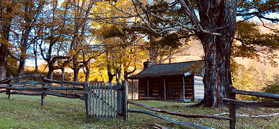
Grayson Highlands, originally named Mount Rogers State Park, was established in 1965. The community overwhelmingly supported this park, beginning with a fund-raising effort for land acquisition and continuing with the donation of items on exhibit in the visitor center. Many areas in the park are named after early settlers. Massie Gap takes its name from Lee Massey, who lived in the gap with his wife and five children in the late 1800s and early 1900s. At that time, the present park area was thinly settled by people who managed to live off the land. They made, grew or gathered most of their necessities.
Wilburn Ridge is named after the famed hunter Wilburn Waters. His reputation as a bear hunter and wolf trapper made him renowned throughout the region.
FRIENDS GROUP
Friends of Grayson Highlands State Park is a nonprofit group of volunteers dedicated to supporting the park.
MASTER PLAN
Master plans must be written for parks before they're built. The plans are updated at least once every 10 years thereafter. The plans cover the size, types, infrastructure and locations of facilities as well as the site's special features and resources. Three public meetings are held during the initial development of each plan. Click here for this park's master plan.
Events, Programs
- 04/18/2026 - Triple Crown Springtime Summit
- 04/22/2026 - High Country Clean Up 2026
- 04/25/2026 - Whose Scat is That?
- 05/08/2026 - Coyote Calls
- 05/10/2026 - Wildflower Wanderers
- More events at this park.

Blogs
- Visiting Grayson Highlands State Park in the off-season
- Holiday shopping at Virginia State Parks
- Is There Glamping at Virginia State Parks? How About a Yurt
- Grayson Highlands State Park: A unique mountain ecosystem
- An iconic southwest Virginia State Parks road trip
- More blogs about this park.
At a Glance


 Trail")


