
Merchandise sales locations will be closed for the required annual inventory beginning Tuesday, April 15 and will reopen when completed on April 16.
Open fires are prohibited throughout the park from midnight to 4 p.m., now through April 30. Learn more.
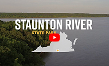
Staunton River State Park
1170 Staunton Trail, Scottsburg, VA 24589; Phone: 434-572-4623; Email: StauntonRiver@dcr.virginia.gov
Latitude, 36.696066. Longitude, -78.685254.


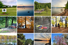
Photos and video

This content takes priority over any other information provided on this park's webpage.
The Visitor Center is open daily 8 a.m. - 4:30 p.m.
Canoe and kayak rentals are available through Hazel Branch Outfitters.
The pool will not open.
Please review the Virginia State Parks Know Before You Go information before you visit.
General Information
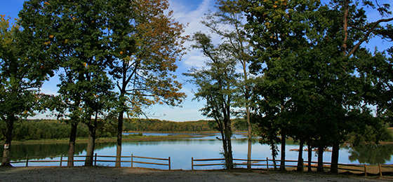
Tucked neatly into the heart of Virginia, about 25 miles from the North Carolina border, Staunton River offers much to families and outdoor enthusiasts. The 2,400-acre park offers woodlands, meadows and shoreline along the Dan and Staunton rivers. Cabins built in the 1930s by the CCC and a campground offer overnight lodging. The equestrian campground offers large campsites and horse stalls. Access to Virginia's largest lake, Buggs Island Lake, offers freshwater fishing and boating, along with water skiing and many other aquatic activities. The park also has picnic shelters, three playgrounds, tennis and volleyball courts, several boat launches and more than 17 miles of multi-use trails.
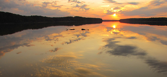
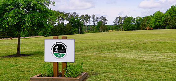
This park is the first state park in Virginia to be designated an International Dark Sky Park and is ideal for stargazing. Park staff conducts associated interpretive programs and rents telescopes. Contact the park for more information on star-watching opportunities.
Hours
The park's open 8 a.m. - 10 p.m.
Location
Staunton River State Park is 18 miles east of South Boston. Take U.S. 360 to Route 344. Follow Route 344 for 10 miles to the park, located southeast of Scottsburg, Va.
Its address is 1170 Staunton Trail, Scottsburg, Va. 24589-9636.
Latitude, 36.696066. Longitude, -78.685254.
Drive Time
Northern Virginia, three and a half hours; Richmond, two hours; Tidewater/Norfolk/Virginia Beach, three hours; Roanoke, two hours
Directions
From the north: Take U.S. 501 south to Halifax, Va. At intersection of U.S. 501 and state Route 360, turn left; go about eight miles. At intersection of state Route 360 and U.S. 360, go straight through the stoplight to Route 344. Travel 10 miles to the park entrance, which is southeast of Scottsburg, Va.
From the south: Take U.S. 501 north to South Boston, Va. At intersection of U.S. 501 and U.S. 58, turn right onto U.S. 58 east; go approximately one mile and turn left at stoplight onto U.S. 360; travel east on U.S. 360 approximately eight miles and turn right onto Route 344; go 10 miles to park entrance.
From the west: Take U.S. 58 east to the intersection of U.S. 58 and U.S. 360; turn left at stoplight onto U.S. 360; go east approximately eight miles and turn right onto Route 344; travel 10 miles to park entrance.
From the east: Take U.S. 360 west to Scottsburg, Va; at intersection of U.S. 360 with state Route 360 and Route 344, turn left at stoplight onto Route 344; travel 10 miles to park entrance.
Park Size
2,336 acres. Buggs Island Lake (Kerr Reservoir): 48,000 acres.
Share this page


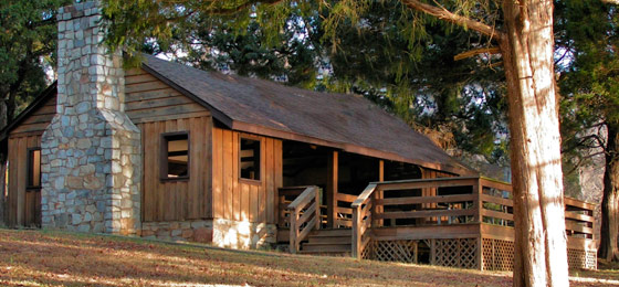
Cabins, camping
OVERNIGHT FACILITIES
Cabins and camping. For information on the availability of overnight accommodations, and particular park amenities or to make a reservation, you can reserve online or call 1-800-933-PARK. Click here for park fees.
Visit a Flickr photoset of typical cabins and lodges at the park. Cabins and lodges vary. Dwellings may not match what's shown in the photos.
Click here for details on reservation cancellation and transfer policies. A fee is charged per pet per night for cabin stays.
Cabins
Between Memorial Day weekend and Labor Day, cabins are rented by the week and rentals start on Sunday. This requirement is reduced to a four-night stay three months out and dropped to two nights in the last month before arrival. A two-night minimum stay is required for the rest of the year.
The park's cabins are on the Staunton River but they are not waterfront. In late fall and early spring, there is a limited view of the water. There is a line of trees between cabins and the water. Boaters should remove boats from the water after use because no docking facilities are near the cabins.
Cabins have:
- Kitchen: Refrigerator, stove, coffeemaker, dishes, silverware, cooking utensils, pots and pans, microwave oven, and toaster.
- Rustic furniture.
- No linens are provided. Guests must bring their own linens and towels.
- Cabins are climate-controlled (heat and AC). Each cabin has a fireplace.
- Living Area: Sofa and dining table
- Bedrooms: Beds, nightstands and clock radios
- Fireplaces
- Heat pumps
- Outdoor fire pit, picnic tables, charcoal grills and decks with patio furniture
- The park's campground bathhouse has a laundry facility. Check with the park's visitor center for the facility's availability during the off-season.
- There are recycling stations throughout the park
- Two vehicles are allowed at each cabin
- Visitors to overnight guests must leave the park by 10 p.m. and are subject to parking fees. They must park in the assigned area if the cabin area already has a maximum of two vehicles parked.
- Firewood is sold at the park.
- There is no access to the rivers or lake in the cabin area.
- Boat launching is free with overnight reservations; however, if your stay depends on launching your boat, please call the park since boat launching is dependent on the water level not being too high or too low.
- Cabin 1 is ADA accessible.
Bring food, towels, coffee filters, salt and pepper, cooking spray, charcoal, starter fluid and any unusual cooking utensils.
Late arrivals: Guests expecting to arrive after 4 p.m. should call the park beforehand.
Total sites of each type: One-room frame efficiency, 1; One-bedroom frame, 2; Two-bedroom frame, 4
Site type:
- Cabins 1 and 2 – Two-bedroom frame – sleeps 4, allows 6. One queen bed, one set of bunk beds.
- Cabins 3 and 7 – One-bedroom frame – sleeps 2, allows 4. One queen bed.
- Cabins 4 and 6 – Two-bedroom frame – sleeps 6. One queen bed, two sets of bunk beds.
- Cabins 5 and 8 – One-room frame efficiency – sleeps 2. One queen bed.
Bunkhouse
Camping Lodge (Bunkhouse) in Campground Area. Two-night minimum.; no full-week requirement. This camping lodge’s maximum occupancy is 14. There’s also a fenced-in campsite (bring your own tent) just behind it that accommodates up to six people. The three-room dwelling has seven bunk beds, a large back deck, picnic tables, a fire ring with a cooking grate and one electrical outlet in each room. There’s no water spigot. Cooking and smoking are not permitted inside the camping lodge (bunkhouse). Parking for up to five vehicles is covered; all other vehicles must pay the park's daily parking fee and park in the overflow area. It’s available during camping season only, from the first Friday in March to the first Monday in December. This facility is not sold 11 months in advance. It becomes available for rent in January. Check-in is 4 p.m., check-out is 10 a.m.
The transfer deadline policy and cancellation and pet fees are the same as those for cabins.
- Linens and pillows are not provided. Guests must bring their own linens and pillows.
- Guests are responsible for any damage.
- There’s no bathroom, kitchen or fireplace.
- It has a refrigerator.
- No cable hookup.
- Heat, air conditioning and ceiling fans are provided.
- No extra bed rentals.
- Camping lodge (bunkhouse) guests use the tent campground bathhouse, which is about 75 yards away.
Camping
Camping is available from the first Friday in March until the first Monday in December.
- Each campsite has fire rings that can be used for campfires or cooking.
- Boat launching is free with overnight reservations, but if your stay depends on launching your boat, please call the park since boat launching is dependent on the water level.
- Firewood is sold at the park.
- Accepts outlets for 20 and 30-amp current.
- Due to the high water pressure in the park, we recommend using a water pressure
regulator. - The laundry facility is in the campground bathhouse. Check with the park's visitor center for the facility's availability during the off-season.
- Recycling stations are throughout the park.
- Check-out time is 1 p.m.
- Visitors to overnight guests must leave the park by 10 p.m. and are subject to parking fees. They must park in the overflow area if the campsite area already has the maximum of two vehicles parked.
- Two vehicles are allowed at the campsite.
- The campground is not on the water. There are no waterfront sites. There is no access to the rivers or lake from the campground. Boaters should remove boats from the water after use as there are no docking facilities in the camping area.
- The bathhouse is heated and has hot showers.
- There are no sewer hookups, but there is a dump station. Do not dump gray water onto the ground. The dump station is located in front of the bathhouse.
- If you need help during the summer months, please see the camp hosts, who are on site number 25.
- All camping equipment (tent, camper, vehicle, trailer, etc.) must be within the timbered-off area of the site.
- Tents must be on the pea gravel on the marked site.
- Vehicles that do not fit on the site must be parked in overflow parking.
- No more than 6 people may occupy one site.
- All sites are site-specific. You must set up on the site you have reserved. If you have issues with your site, please report to the Visitor Center or contact the Ranger on Duty.
- Quiet hours are from 10 p.m. to 6 a.m. If there is an issue with someone following this rule, please notify the Ranger on Duty.
- Trash dumpsters are located behind the boat storage area at the Staunton River boat launch. Please do not leave trash on your site.
- Because we are a Dark Sky park, we try to pollute the sky as little as possible. Please refrain from burning outside lights from 10 p.m. to dawn.
- Fires must be confined to grills, camp stoves, or designated fire rings. Never leave a fire unattended. Please extinguish the fire after use.
- From March 1st through April 30th, open-air fires including fire rings are prohibited except between the hours of 4 p.m. and midnight. We enforce all seasonal and emergency bans.
- State law permits the use of alcohol only in private areas. (INSIDE your cabin or camping unit)
Total sites of each type: EW 45-ft, 4; EW 30-ft, 10; EW pop/tent, 20; Tent Std., 13
Site type:
EW 30-ft - Electric and water hookups, various equipment up to 30 feet, bathhouse available.
EW Pop/Tent - Electric and water hookups, various equipment up to 20 feet, bathhouse available.
EW 45-ft - Electric and water hookups, various equipment up to 45 feet, bathhouse available.
Tent Std - Tents only, no hookups, bathhouse available.
Total campsites: 48 (including camp host site)
Equestrian Camping: Electric and water hookups and a central dump station are available. Sites 1-10 are pull-through with paved surfacing and can accommodate a camping unit up to 55 feet long and one vehicle. Sites 11-13 are back-in with a gravel surface and a tent pad and can accommodate camping units up to 45 feet long with one vehicle. There are 20 covered horse stalls, a bathhouse with showers and a picnic shelter. Picnic tables, fire rings and charcoal grills are available at each site.
Campground Map
- All sites are site-specific. You must set up on the site you have reserved. If you have issues with your site, please report to the Visitor Center or contact the Ranger on Duty.
- All sites have electric pedestals, which have 20, 30 and 50-amp outlets.
- Due to the high water pressure in the park, we recommend using a water pressure
regulator. - All equipment must be kept on the paved or graveled area at the campsite.
- Proof of a negative Coggins test is required.
- Horses must be kept in a stall when not being ridden. Horses may not be tied up in open areas, day-use areas or around the campsites. Horses may only be ridden on designated trails and are not permitted on paved roads within the park.
- Pets must be kept on a leash no longer than 6 feet and attended to at all times.
- Check-out time is 1 p.m.
- Quiet hours are from 10 p.m. to 6 a.m. If there is an issue with someone following this rule, please notify the Ranger on Duty.
- Because we are a Dark Sky park, we try to pollute the sky as little as possible. Please refrain from burning outside lights from 10 p.m. to dawn.
- To reserve a stall, a member of your party must have a campsite reserved in the EQ campground.
- There is one horse per stall.
- It is the guests’ responsibility to clean the stalls prior to check out. Wheelbarrows, buckets, rakes, and pitchforks are available. Please have your stall cleaned for the next guest.
- If you find a stall that has not been cleaned, please notify the Visitor Center.
- From March 1st through April 30th, open-air fires including fire rings are prohibited except between the hours of 4 p.m. and midnight. We enforce all seasonal and emergency bans.
- State law permits the use of alcohol only in private areas. (INSIDE your cabin or camping unit)
- Two vehicles are allowed at the campsite.
- There is a dump station at the EQ campground. Please do not dump gray water onto the ground. The dump station is located on the right-hand side of the entrance at the EQ campground.
Recreation
TRAILS
Hiking and self-guided trails; horses are allowed on the multi-use trail. Ten wooded trails provide miles of hiking along the Dan and Staunton rivers as well as Buggs Island Lake. Multi-use trails are open for hikers, bikers and horseback riders. Bring your own horse and bike.
Note: Trails are often closed during wet conditions to prevent damage to the park's trails. Please call the park at (434) 572-4623 prior to your visit to ensure that the trails are available for use.
SWIMMING
There are no designated swimming areas in the park.
FISHING, BOATING
The Dan and Staunton rivers and Buggs Island Lake are famous for the number and size of fish there. Bass, bluegill, crappie and perch are plentiful. The park has a boat launch. A Buggs Island Special Pass that covers boat launching and parking for Occoneechee and Staunton River state parks is available. A valid Virginia fishing license is required; purchase one in the park's visitor center. Annual boat launch passports are available by calling 1-800-933-PARK.
No boat rentals at this park. Guests must bring their own boats. Hazel Creek Outfitters offers canoe and kayak rentals. They will deliver to the park. Check them out at https://www.hazelbranchoutfitters.com/ Boat launching ramp is available. These facilities may not be accessible if the water level is too high or low. If your visit depends on the ability to launch your boat, please call the park in advance. Both motorized and non-motorized boats are permitted on Buggs Island Lake. Click here for park fees.
ASTRONOMICAL OBSERVATION
The park was designated as the 25th International Dark Sky Park by DarkSky International in July 2015. The park hosts guided observing sessions monthly throughout the summer and sessions for special astronomical events throughout the year. The Chapel Hill Astronomical Observational Society has donated two Newtonian-reflector telescopes that may be rented at the visitor center. The rental includes the telescope, two lenses, a star map, printed instructions and a hands-on tutorial by park staff.
The park hosts the Staunton River Star Party and the Chapel Hill Astronomical Observational Society every March and October. Registration is required; however, each Saturday night during the event is free and open to the public.
A field next to the visitor center is available year-round for astronomical observation. Parking fees apply. Contact the visitor center for more information.
HORSES
Horses must be kept on designated trails and are not allowed on park roads, in camping areas or in day-use areas. Horseback riders are allowed on a multi-use trail. There are no horse rentals in the park or nearby, but there are overnight facilities for horses at the park. State law requires that visitors carry a copy of a negative Coggins report with each horse brought to the park.
DISC GOLF
Staunton River is home to a challenging, woodsy nine-hole disc golf course.
Park Trail Guide
Click here for the park's trail guide.
Click here for its general facilities guide.
Download (external link for use with Avenza App) the geo-referenced map
Download the geo-referenced map for this park
Nearby Attractions
- South Boston Museum
- South Boston Speedway
- Staunton River Battlefield State Park
- Hunting Creek Vineyards offers wine tastings, tours and wine sales.
- Springfield Distillery offers handcrafted spirits and food trucks.
- Visit www.gohalifaxva.com for current local offerings.
Picnic Shelters
Shelters can be rented from 8 a.m. to 10 p.m. Call 1-800-933-PARK to reserve. Parking fees are not included in shelter rental. Click here for park fees.
Cancellation policy: No refund within 14 days before reserved date. Before then, there's a cancellation fee. The policy applies as well to the park's two mini-shelters described below.
Amenities: Both shelters have grills, picnic tables and access to nearby restrooms.
Shelter 1: Near the Dan River, this shelter provides a shady setting for reunions, picnics and other special events. It accommodates up to 60 comfortably. There is a spigot that allows access to potable water and a large grill at the back of the shelter. There's no deck but there is a graveled area by the grill. This shelter offers no view of the river; access to the river is limited. A walk of about two minutes brings you to the river. The shelter is near a playground, horseshoe pit and trash disposal, and bathrooms are about five minutes away. First-come, first-served picnic tables that can be used to accommodate more people are around the shelter. (Note: Several distances mentioned above might prove difficult for the disabled.)
Shelter 2: Beside the Dan River, this shelter provides a shady setting for reunions, picnics and other special events. It accommodates up to 60 comfortably. There is a spigot that allows access to potable water and a large grill at the back of the shelter. First-come, first-served picnic tables that can be used to accommodate more people are around shelter. This shelter has a spacious deck near the grill and offers a waterfront view and easy access to the water. There is a boat launch that can be used when the water level is high, but users must pay a launching fee. Also, the shelter features a playground, horseshoe pit and trash disposal, and universally accessible bathrooms are only a short distance away. The shelter is not, however, equipped with a ramp for easy access by the disabled. Spacious grounds for softball, badminton, soccer, etc., are nearby. Guests must provide their own equipment.
Turkey Trail mini-shelter 1: This small picnic shelter, open from 8 a.m. to 10 p.m. March 1 through Nov. 30, allows up to 15 people. It can be rented all day for a small fee. The 18 by 20-foot structure is covered, with all sides open, and has a 12-foot table, a 6-foot table and one small charcoal grill. It’s near a water spigot, restrooms and a trash bin. The shelter is not universally accessible.
Deer View mini-shelter 2: This small picnic shelter, open from 8 a.m. to 10 p.m. March 1 through Nov. 30 annually, allows up to 15 people. It can be rented all day for a small fee. The 18 by 20 foot structure is covered, with all sides open, and has a 12-foot table, a 6-foot table and one small charcoal grill. It’s near a water spigot, restrooms and a trash bin. The shelter is not universally accessible.
Meeting Space and Facilities
MEETING FACILITIES
None at this park.
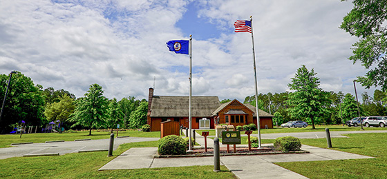
VISITOR CENTER, GIFT SHOP
The visitor center, which was originally built by the Civilian Conservation Corps in the 1930s, was extensively renovated in 2009. Today the building houses the Discovery Center, a gift shop and park offices.
RESTAURANT
None. This park has a snack bar in season.
LAUNDRY
The campground bathhouse has laundry facilities. Check with the visitor center for availability during the off-season.
ENVIRONMENTAL EDUCATION CENTER
None at this park.
SPECIAL FEATURES
Tennis courts and volleyball courts. There's also a playground behind the visitor center. Shelters have a playground and horseshoe pits. Rent tennis rackets, volleyballs and horseshoes at the visitor center.
The park also has a disc golf course. It runs through various areas of the park. Most of the course runs along River Bank Trail, but it branches off in some places to provide some seclusion. Players may warm up at the park's practice basket or in nearby fields. The visitor center rents and sells discs consigned by Off the Chains in South Boston, Virginia, and Dynamic Discs of Kansas.
Other Info
ACCESSIBILITY:
- Visitor center
- District park office
- Boat launch located on the Dan River side. The dock on the boat launch is universally accessible. (There is no particular device, however, to assist in the entry of a boat.)
- Picnic shelter 2 is not universally accessible. The bathrooms for this shelter are, however. Of the two shelters, this one is most convenient for those who are disabled.
- The campground is not universally accessible. The bathhouse for the campground, however, is. There is a sidewalk leading from the road to the bathhouse. Sites 22 and 24 are the most convenient for RV camping; sites 23 and 27 are the most convenient tent and pop-up sites. Both are level and easily accessed, and both are close to the bathhouse.
- The cabins are not universally accessible. The doorways into the cabins and into the bathrooms are not large enough for a wheelchair. The most easily accessed cabins are #2 and #5. The cabins' bathrooms are not universally accessible.
- Although motorized vehicles are not permitted on park trails, electric wheelchairs and electric scooters that meet the federal definition for wheelchairs are allowed to enable people with disabilities to use the trails.
NATURE, HISTORY PROGRAMS
Guided hikes, evening amphitheater programs, canoe trips, and guest speakers/entertainers. Call the park for details. Click here to view all parks' events, festivals, workshops and interpretive programs.
CONCESSIONS
None at this park.
HISTORY
Staunton River State Park takes its name from a river that borders the park. The river was named for Captain Henry Staunton who, before the Revolutionary War, commanded a company of soldiers to protect early settlers from Indian attacks. The soldiers patrolled from the mountains to the mouth of the Dan River. This section of the Roanoke River became known as Captain Staunton’s River and later, Staunton River. Forty years later, in the 1810s, the river became an important means of transporting tobacco, a popular cash crop. Many large plantations were built in the area. During the Civil War, most of these plantations were destroyed.
In 1933, Virginia's Commission of Conservation and Development bought 1,766 acres of farmland bordering the river from several owners. From 1933 to 1935, a unit of the Civilian Conservation Corps (CCC) built most of the buildings and facilities that are still seen today at the park. The CCC barracks were near what is today a nature trail in the park. The park opened on June 15, 1936. Buggs Island Lake was formed with the construction of the Kerr Dam in 1952. Although the creation of Virginia's largest lake was an asset to the park, more than 150 acres of the original park lands were flooded.
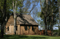
Staunton River State Park was recognized in 2007 as a National Historic Landmark and a Virginia Historic Landmark. Many structures in the park, including the cabins, visitor center and picnic shelters, are little changed from when they were built by the Civilian Conservation Corps in the early 1930s.
The park continues to grow. A recent land purchase has increased its size to 2,400 acres. Facilities are modern and well-maintained, but Staunton River State Park remains true to its roots. Its sturdy structures honor and memorialize CCC members who worked so hard to build them.
FRIENDS GROUP
None.
MASTER PLAN
Master plans must be written for parks before they're built. The plans are updated at least once every 10 years thereafter. The plans cover the size, types, infrastructure and locations of facilities as well as the site's special features and resources. Three public meetings are held during the initial development of each plan. Click here for this park's master plan.
Events, Programs
- 04/12/2025 - Beautiful Bluebird Babies
- 04/16/2025 To 04/25/2025 - Lyrids Meteor Shower
- 04/19/2025 To 05/28/2025 - Eta Aquarids Meteor Shower
- 04/22/2025 - Earth Day Ranger-Led Hike
- 04/26/2025 - Earth Day Upcycling - Paint Your Own Vase
- More events at this park.

Blogs
- Fishing at Virginia State Parks
- First Master Paddler of Virginia State Parks: Colleen Renderos
- Holiday shopping at Virginia State Parks
- Trail running through Trail Quest: Q&A with Master Hiker, Jessica Hairfield
- 5 things to do in the forest for fall break
- More blogs about this park.
At a Glance


