 Department of Conservation and Recreation
Conserve. Protect. Enjoy.
 Department of Conservation and Recreation
You want to build a house and need to know if the land is suitable. Or maybe you'd like to know which grasses, shrubs and trees would thrive there. Which vegetables will be most fruitful?
Let's say you're a farmer and you're thinking about renting neighboring farmland to grow crops and hay. Which fields might be best suited for growing corn, soybeans and alfalfa?
You can find answers to such questions in a soil survey.

Soil is a mixture of mineral and organic matter, air, water and living things. There are about 500 different soils in Virginia.
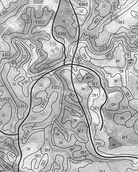
A soil survey, made on a county basis, is a scientific inventory of these soils. This inventory includes maps that the show soil's location and type, detailed descriptions of each soil and laboratory data on many physical and chemical properties of the soil. The data can be used to make decisions on how to use the land.
Homebuyers and owners can avoid costly mistakes by using soil surveys. These surveys show the extent and hazards of flood-prone areas, give the amount of sand, silt and clay in soil, and rate the shrinking and swelling potential of soils high in clay content. They also detail erodibility, slope, permeability, wetness, depth to bedrock and water tables to determine, for example, whether a septic tank absorption field can be safely installed.
Planners and engineers can also use this information in evaluating soil problems along with other land use alternatives in choosing the best sites for highways, shopping centers, subdivisions and other facilities of urban and industrial development.
Farmers can use survey information to identify important agricultural land and to decide which conservation methods will keep it in high production.
Soil surveys also offer valuable planning information to:
Visit the Natural Resources Conservation Service (NRCS) website to see which counties have published soil surveys. Completed soil surveys may also be available from your local NRCS office or your local soil and water conservation district office. Many libraries have their locality’s soil survey as well.
The NRCS Web Soil Survey is an online mapping application that allows you to view soil surveys that have digital spatial data. Check availability of this online spatial data using this map.
If you use a geographic information system (GIS), download data from the NRCS Geospatial Data Gateway. This is the same data available for viewing on the Web Soil Survey site.

